| Alternative Station Sites |
"Wye"
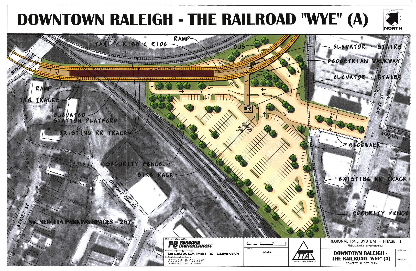
(A)
Refered to as the Wye Location
Endorsed by Committee on Dec 12/2001
Elevated in the southeast portion of the
railroad 'Wye', south of Hargett St. |
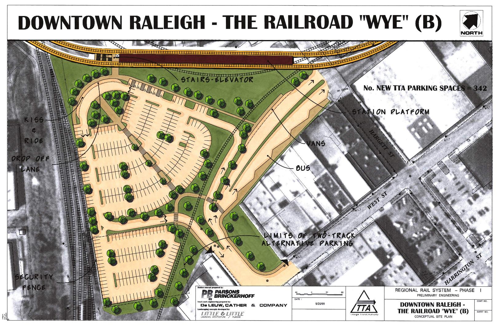
"Wye"(B)
Elevated in the center of the railroad 'Wye',
south of Hargett Street |
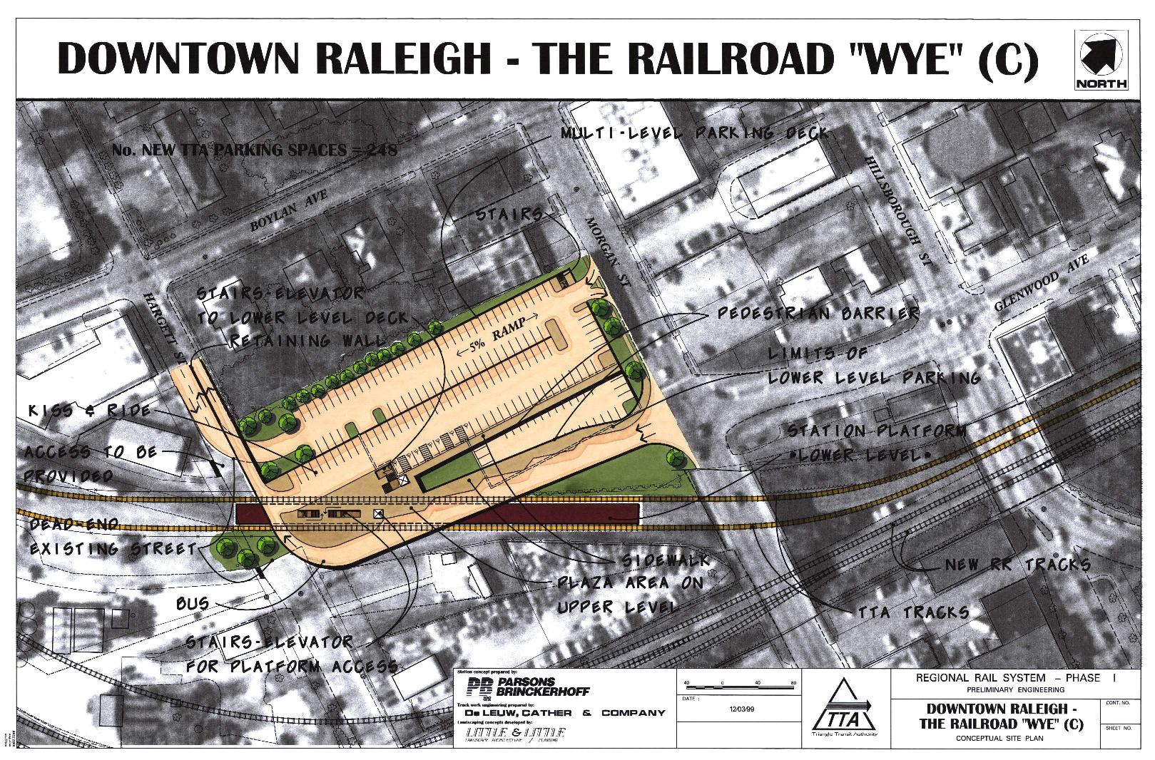
"Wye"
(C)
Refered to as the Morgan Street Station
At ground level, between Morgan and Hargett
Streets, just west of the rail corridor |
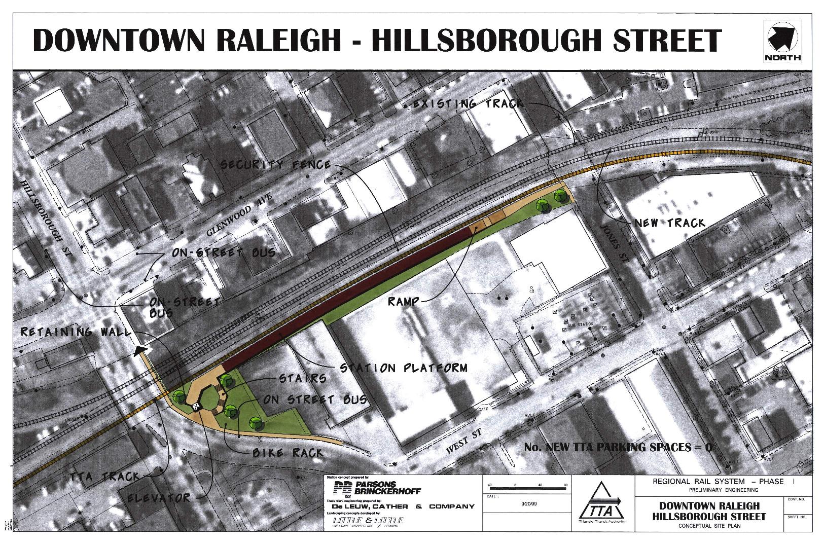
Hillsborough
Street
At ground level, north of the Hillsborough
Street Bridge |
|
 |
 |
 |
 |
| ENVIRONMENTAL IMPACT POTENTIAL |
| Displacement
/ Relocation |
One
building within the Wye and 3 buildings on the east edge of the Wye, west
of West Street, all these buildings are owned by the Dillion Supply
Company and include 3 other businesses; Hartsfield Auto Repair |
One
building within the Wye and a building on the north corner of Martin
Street, both of which are owned by the Dillion Supply Company; a Ready Mix
Concrete Company building; Goodwin Sand & Gravel Company; Hartsfield
Auto Repair |
The
Shelton Furniture Company and Curve Makers (in one building between
Hargett and Morgan Streets); a Ready Mix Concrete Company building;
Goodwin Sand & Gravel Company |
Hartsfield
Auto Repair |
| Noise Sensitive Places within 300 feet |
None |
None |
Seven
homes |
Saint
Paul A. M. E. Church, which is listed on the National Register of Historic
Properties |
| Environmental
Justice Issues |
The
population in the 1990 census block groups that are within 1/2 mile of the
station site is about 48% minority, compared with the general population's
average of 32 %; the actual census block containing the station is about
18% minority; about 10 % of the station block group population is
low-income |
The
population in the 1990 census block groups that are within 1/2 mile of the
station site is comparable to the general population's average of 32%; the
census block group containing the station is about 32% minority and 50%
low-income. |
| Visual Effects |
Industrial
view replaced with a station view from the Boylan Heights Neighborhood |
Industrial
view replaced with a station view from the Boylan Heights Neighborhood |
Industrial
view replaced with a station view from the Boylan Heights Neighborhood |
None |
| Cultural
& Historic Resources |
| Historic
Properties |
No
historic properties or districts will be displaced or directly affected;
the trackwork will be close to but not within the Boylan Historic
District; the station site is adjacent the proposed industrial Depot
Historic Overlay District which includes one National Register Study List
property |
No
historic properties or districts will be displaced or directly affected;
the trackwork will be close to but not within the Boylan Historic
District; the station site is adjacent the proposed industrial Depot
Historic Overlay District which includes one National Register Study List
property |
No
historic properties or districts will be displaced or directly affected;
the station site is adjacent to the South Boylan Historic District, which
has been recommended for National Register Eligibility |
No
historic properties or district will be displaced or directly affected;
the station site is within a potentially proposed Central Raleigh Historic
District; near-by or adjacent historic resources include the (former)
Raleigh Electric Company Building, St. Paul A.M.E. Church, the
Dodd-Hinsdale House |
| Parks
and Natural Systems |
No
parks, wetlands, streams or endangered species are impacted |
No
parks, wetlands, streams or endangered species are impacted |
No
parks, wetlands, streams or endangered species are impacted |
No
parks, wetlands, streams or endangered species are impacted |
| Hazardous
Materials & Underground Tanks |
There are
no hazardous materials or underground storage tanks on the site;
registered underground storage tanks exist near the site |
There are
no hazardous materials or underground storage tanks on the site;
registered underground storage tanks exist near the site |
There are
no hazardous materials or underground storage tanks on the site;
registered underground storage tanks exist near the site |
There are
no Hazardous Materials or underground tanks on the site; registered
underground storage tanks exist near the site; a leaking tank is recorded
one block from this station site |
| Plan Compatibility |
| Plans/zoning
Supportive of Increased Density and Mixed Uses |
This site is within the
City's Regional Intensity Area, designated to support intense, mixed-use,
transit-oriented development; this location is also consistent with the
adopted location for the City's proposed Intermodal Terminal Facility
within the Wye |
This site is within the
City's Regional Intensity Area, designated to support intense, mixed-use,
transit-oriented development; this location is also consistent with the
adopted location for the City's proposed Intermodal Terminal Facility
within the Wye |
This
site is within the City's Regional Intensity Area, designated to support
intense, mixed-use, transit-oriented development; the City's adopted plans
locate the Intermodal Terminal Facility within the Wye, generally south of
this station site |
This
site is within the City's Regional Intensity Area, designated to support
intense, mixed-use, transit-oriented development; the City's adopted plans
locate the Intermodal Terminal Facility within the Wye, and this site is
north of the Wye |
| Compatible with
Existing Land Use |
Yes |
Yes |
This
station site would not be compatible with adjacent residential land uses;
it would bring bus and auto traffic into this partially residential area |
Yes |
| Enhances Investment
/ Reinvestment |
The
acquisition of property (business displacement) on the north and south
sides of Hargett Street would support economic development by bringing
these properties onto the redevelopment market thereby returning the value
of the infrastructure investment to the general public and the private
sector |
The
properties acquired (business relocations) as a result this option will be
used for trackwork and station facilities |
The
property acquired (business dislocation) as a result of this option will
be used for trackwork and station facilities |
No
property acquisition is anticipated at this location; while almost all the
parcels directly adjacent to the site are developed, the location of a
station at this site is could have a positive effect on the ongoing
reinvestment in the Glenwood South Corridor |
| Accessibility |
| Residents
within Walking Distance |
About
9,200 people live within the 1990 census block groups within 1/2 mile of
the station; more than 4,800 live within the block groups within 1/4 mile |
About
9,200 people live within the 1990 census block groups within 1/2 mile of
the station; more than 4,800 live within the block groups within 1/4 mile |
About
9,200 people live within the 1990 census block groups within 1/2 mile of
the station; more than 4,800 live within the block groups within 1/4 mile |
About
4,300 people live within the 1990 census block groups within 1/2 mile of
the station and almost 2,900 live in the block groups within 1/4 mile |
| Site Visibility from Major Roads |
The
station site would be visible from Boylan Avenue, Martin, West and Hargett
Streets |
The
station site would be visible from Boylan Avenue, Martin, West and Hargett
Streets |
The
station site would be visible from Boylan Avenue, Hargett and Morgan
Streets |
The
station site is hidden behind buildings, but would be visible to
pedestrians from the Hillsborough Street bridge |
| Bicycle
Access |
Boylan Avenue, Hargett and
Martin Streets are all designated bike routes |
Boylan Avenue, Hargett and
Martin Streets are all designated bike routes |
Boylan Avenue, Hargett and
Martin Streets are all designated bike routes; this alternative would
close Hargett Street to vehicles and pedestrians between Boylan Avenue and
West Street |
Boylan Avenue, Hargett,
Martin and Hillsborough Streets are all designated bike routes |
| Pedestrian
Access |
Downtown
transit patrons would access the elevated platform via elevators and
stairs; direct pedestrian access will be provided off of Boylan Avenue |
Downtown
transit patrons would reach the elevated platform via elevators and stairs |
Downtown
transit patrons would reach the platform from the parking garage deck
above the platform, via elevators and stairs; pedestrian access to the
parking garage would be along Morgan Street (from both east and west) and
Hargett Street (from the west) |
Downtown
transit patrons would have at-grade access off of Jones Street; stairs and
ramps would provide connections to Edenton and Hillsborough Streets |
| Access
to the Raleigh Intermodal Terminal Facility |
Readily
connects to the proposed Facility, as well as overland coach, bus, taxi
and current Amtrak Passenger Station |
Readily
connects to the proposed Facility, as well as overland coach, bus, taxi
and current Amtrak Passenger Station |
Does not
connect to the proposed Facility; a 700 foot pedestrian overpass could be
provided to create a connection |
Does not
connect to the Intermodal Terminal Facility |
| DESIGN ISSUES |
| Trackwork |
This
option meets the NCDOT Intercity Rail Service trackwork improvement goals
by providing room for future proposed freight and High Speed Intercity
rail track improvements; it would not require changes to the existing
railroad tracks or operations; trackwork would include a flyover within
the rail corridor through the Wye; alterations
to the Morgan Street bridge substructure and redesign of portions of the
Hillsborough Street bridge would be required |
This
option does not meet the NCDOT Intercity Rail Service goals; it requires
substantial changes in the existing railroad tracks but would have low
disturbance of the existing railroad operations; trackwork would include a
flyover within the rail corridor through the Wye, and some alterations to
the Morgan Street bridge substructure |
This
option meets the NCDOT Intercity Rail Service trackwork improvement goals;
it would require substantial changes in the existing railroad tracks and
major changes to the existing railroad configuration and operations; it
would require TTA's acquisition of the Norfolk Southern Railroad
right-of-way to Fuquay, which is considered to be a substantial, it not
impossible hurdle; the Hillsborough Street bridge would require redesign;
the flyover is shifted to north of the Hillsborough Street bridge |
This
option could meet the NCDOT Intercity Rail Service trackwork improvement
goals; only one TTA track is feasible at this site, constraining future
regional rail service improvements |
| Operational Efficiency |
Low
disturbance to existing railroads |
Substantial
changes in existing railroad tracks |
Substantial
changes to existing railroad tracks and operations |
Low
disturbance to existing railroads; with a station at this site TTA would
be limited to single track operation, which will constrain service
improvements (headways/frequency of trains) in future phases of the
Regional Rail Service, and therefore limit the long term benefit of this
transit investment |
| Cost |
A station
at this site and related operations would require a long flyover,
including the elevated station platform, but no changes to existing
trackwork; the Morgan Street bridge substructure would be altered at the
east abutment |
A station
at this site would require a long flyover, including the elevated station
platform along with extensive railroad track relocation for vertical and
horizontal clearances; the Morgan Street bridge substructure would be
altered at the east abutment |
A station
at this site would require the flyover to be shifted to north and east of
Jones Street; extensive trackwork changes would be required to maintain
Norfolk Southern operations; parking and bus operations would require a
structure |
A station
at this site would require railroad relocations between Hillsborough
Street and Boylan Avenue; the flyover would be shorter and lower than the
one required for the elevated stations within the Wye |
| Station Facilities |
Sufficient
at grade-parking can be constructed for double and single track operations
thereby reducing initial development costs; and preserving
joint-development options |
Sufficient
at grade-parking can be constructed for double and single track operations
thereby reducing initial development costs; and preserving
joint-development options |
A
parking garage must be constructed to obtain sufficient parking for single
and double track operation thereby excluding joint-development options
subsequent to service commencement |
No
designated parking is provided at this site |
| TRAFFIC FLOW ISSUES |
| Changes
in Street Network |
Martin Street would be
extended towards the Wye connecting the station parking and access area to
West Street |
Martin Street would be
extended towards the Wye connecting the station parking and access area to
West Street |
This option would result in
the closure of Hargett Street, (two-way), between West Street and Boylan
Avenue, shifting traffic to Morgan Street (one-way east-bound) and
Hillsborough Street |
None |
| Vehicular
Access |
All vehicles would access
the station from one entrance on Martin Street, which extends into the Wye;
this entry was selected because it crosses the railroad track with the
lowest volume in the Wye; bus parking directly below the platform is
limited, but drop-off and pick up could also take place along West Street,
using sidewalks to connect to the platform stairs and elevator; good
circulation is provided for all vehicles; an at-grade railroad crossing
would be introduced at the south end of the Boylan Avenue bridge |
All vehicles would access
the station from Martin Street; this entry was selected because it crosses
the railroad track with the lowest volume in the Wye; only transit
vehicles would exit onto Hargett Street where the railroad tracks would be
relocated westwards to avoid the bus operations area; good circulation is
provided for all vehicles; an at-grade railroad crossing would be
introduced at the south end of the Boylan Avenue bridge |
Transit vehicles and cars
would have separate access to the parking deck and
bus ramp from Morgan Street (one way east-bound) and Hargett Street
which would be closed to through traffic at Boylan Avenue; good
circulation is provided for all vehicles; station traffic would be
introduced to the residential streets adjacent to this site |
There is no direct
vehicular access to the station platform; bus, taxi and kiss-and-ride
operations will take place on-street |
| Parking |
Park and
ride, kiss and ride, bus, taxi and other intermodal connections are
anticipated to take place on-site; on-street intermodal connections could
also occur on West and Martin Streets |
Park and
ride, kiss and ride, bus, taxi and other intermodal connections are
anticipated to take place on-site; on-street intermodal connections could
also occur on West and Martin Streets |
Park and
ride, kiss and ride, bus and taxi are anticipated to take place on-site |
This site
is adjacent to a parking deck; no designated parking would be provided for
this station site; (kiss and ride, bus and taxi are anticipated to take
place on-street) |